Climate-adapted groundwater management through real-time planning tools and model-based future scenarios
Brief description
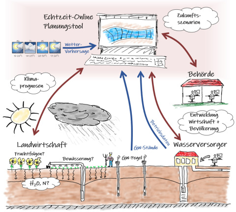
The project develops tools to support water utilities and government agencies to optimize the operational management and long-term planning of groundwater management. The impact of climate-driven changes in land management on groundwater recharge and leachate quality will be investigated. Models for groundwater recharge, nitrogen loads, groundwater levels, catchment areas of catchments, and flow times will be developed to calculate climate and land use change scenarios and simulate management strategies including groundwater use prioritizations. Data assimilation provides an always up-to-date model with web interface for short-term to seasonal planning. The results of the scenario analyses and the planning tool provide utilities and agencies with user-friendly tools to make decisions based on science in an environment of increasing conflict and extreme weather.
The study area includes a karst aquifer and a gravel aquifer in the vicinity of Tübingen, each with several utilities. The project maps different site conditions (geology/land use), management issues, and use conflicts. After successful demonstration, the approach can be transferred to other groundwater management areas.
Objectives
GW_4.0 will develop model planning and decision support tools for seasonal to long-term groundwater management of the Upper Gaeu and Neckar Valley near Tübingen. Long-term trends in groundwater supply and demand will be estimated so that the water needs of households, industry and agriculture can be met sustainably. An online real-time planning tool will enable medium-term planning such as seasonal prioritization of groundwater use and optimization of operational use.
The projections of the expected development of relevant factors for groundwater supply and quality and the online real-time planning tool are intended to provide authorities and water suppliers with user-friendly decision-making tools to support approval procedures and to manage operations on the basis of scientifically sound forecasts.
GW_4.0 is closely coordinated with local stakeholders responsible for groundwater management and is intended to further develop existing tools for quantitative assessment and planning of management (soil water balance model GWN-BW, existing groundwater flow models, etc.).


